Town of Tisbury Master Plan (DRAFT) August 5, 2004
Upper State Road Suggested Planning Alternatives
June 30, 2004
Connector between State Road and
EdgartownRoad
One of the most pressing issues raised by
the community has been the congestion along the Upper State Road corridor and a
corresponding concern about the image of strip commercial development and urban sprawl
that is associated with it. Both popular opinion and the MVC’s technical reports
suggest we consider a connector road between State and Edgartown roads to alleviate the
problem.
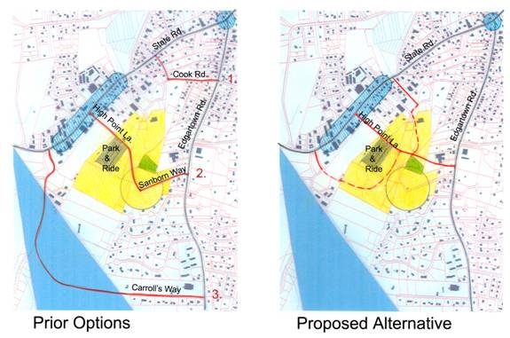
Figure 4 Connector
Road Options
Previous studies have considered three routes between the two roads:
***
Previous studies have considered
three routes between the two roads:
1. Using Cook Road to Oak Hill. This is the shortest route but, while it avoids the
dangerous intersection at Look Street, it returns all of the traffic back into the State
Road corridor. It also would disrupt the residential neighborhood in this area.
2. Using Sanborn Lane going past the town
well, through the town landfill area and connecting to High Point Lane –
approximately at the center of the business district.
This route is more effective and uses primarily town land, but unfortunately
passes through a zone 1 water protection area so it is not a practical option. Moreover,
vehicles attempting to by-pass the area are still mixed-in with vehicles going to the State
Road businesses.
3. Use Carrolls’s Way going through
the Oak Bluffs wedge to a connection with Holms Hole Road. This option moves the traffic
entirely beyond the State Road business district which helps people traveling up-island.
However, much of the traffic on State Road is headed for the business district so those
vehicles would have to double back to get to their destination. Moreover, the route is problematic in that it
would require the acquisition of a lot of private land both in Tisbury and in Oak Bluffs.
Finally, it invites sprawling development into a significant habitat area by inserting a
road into a currently undeveloped part of the town.
***
The proposed alternative recommends a system of streets that
begins with a connector near the Edgartown Bank, the NSTAR power lines and/or IFP property
leading up past the MV Land Bank property to the town land. There it splits into three
separate ways allowing drivers to sort themselves out according to their destination. The
main branch travels past the Park and Ride lot to High Point Lane; those traveling
up-island branch to the left around the landfill and on to Holmes Hole Road; and those
going toward Pine Tree Road branch to the right and proceed past the DPW building to
Evelyn Way.
Most of this corridor lies within town land and consequently avoids
the issues of major acquisitions or of opening up undeveloped areas for new construction.
Preliminary studies indicate that such a
road would reduce the traffic on the State Road corridor by as much as 25%.
********************************************************************