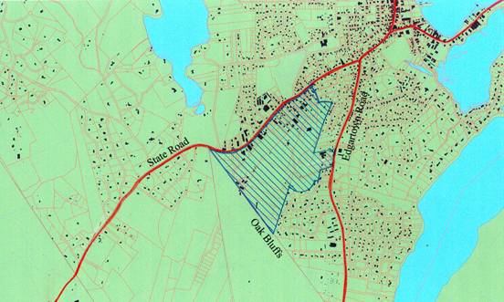
Figure 1 Study Area -
Upper State Road - Suggested Planning Proposals
For the last year and a half, the Tisbury Planning Board has been working on a new master plan for the town. We began the process with an extensive questionaire that was sent to all of the town's year-round residents, as well as many of our summer residents, and we were pleased to get an overwhelming 42% response.
Included below are a series of
recommendations for the land uses in and around Upper State Road that we would like you to
review. We have presented these ideas to the
property owners in the area, town officials, the Martha's Vineyard Commission, and others. At this point, we would very much like to hear your
ideas. Please email your comments to XXXXX@ci.tisbury.ma.us
Thank You
Tisbury Planning Board
_____________________________________________________________________________
*****************************************************************************
_____________________________________________________________________________
*****************************************************************************
Index:
Introduction
Land Use Plan
Establish a Transit Node at the Park and Ride lot
Shuttle Bus Route
Fire Department and Emergency Services
Expand commercial development along High Point
Road
Designate a Motor Vehicle Zone in a section of the former landfill.
Local Street System
Neighborhood Street Systems - Develpment Alternatives
Housing Opportunities
Open Space Preservation and RecreationSummary of Land Use Proposals
_____________________________________________________________________________
*****************************************************************************
Figure 1 Study Area -
Several major issues -traffic congestion, transit options, municipal services, new housing development, open space preservation, economic growth – all converge on a small section of town bounded approximately by State Road, Edgartown Road, Cook Rd. and the Oak Bluffs Town Line.
Adjacent to this corridor we have much more marginal uses - the
former landfill, a new septic treatment plant, the town well, warehouses and light
industry and a large amount of land that is either vacant or is used to store trucks,
busses, used cars and abandoned automobiles. Unlike
more remote parts of town, this is not pristine land. It has been filled-in, dug-up and
built-over extensively.
This area was once the outskirts of town but the growth of businesses
on
The fact that these diverse conditions overlap – a local town center adjacent to a marginal, semi-industrial area – creates some interesting opportunities that we should explore:
Ę Reducing traffic congestion and increasing public safety.
Ę Encouraging the use of mass transit.
Ę Creating opportunities for new housing especially affordable housing.
Ę Adding to our open lands, not diminishing them.
Ę Repairing and restoring those portions of our streets and landscape that have been disrupted by recent developments.
Ę Improving the overall visual quality of the town.
Ę Finding ways for the town to grow while preserving its village character and protecting its open spaces.
_____________________________________________________________________________
*****************************************************************************
Below are a series of suggestions for addressing these issues:
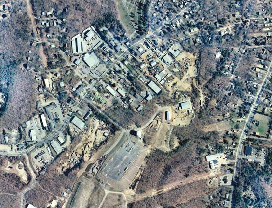
Figure 2 Aerial Photo - Upper State Road Business
District
_____________________________________________________________________________
*****************************************************************************
Land Use Plan
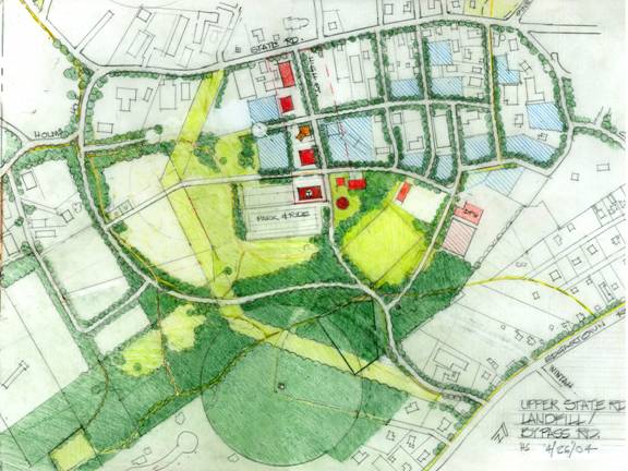
Figure 3 Proposed
land uses for the
•
Build a
connecting road system linking
•
Create a
transit center at the Park and Ride lot.
•
Extend
commercial development along
•
Relocate
emergency services to the area.
•
Create a motor
vehicle storage area within the landfill.
•
Expand
residential development / Look for affordable housing possibilities.
• Restore the landscape
• Increase open spaces and preservation lands
•
Expand
recreational opportunities.
_____________________________________________________________________________
*****************************************************************************
Connector between
One of the most pressing issues raised by
the community has been the congestion along the
Figure 4 Connector
Road Options
Previous studies have considered three routes between the two roads:
***
Previous studies have considered three routes between the two roads:
3. Use Carrolls’s Way going through
the Oak Bluffs wedge to a connection with
***
The proposed alternative recommends a system of streets that
begins with a connector near the Edgartown Bank, the NSTAR power lines and/or IFP property
leading up past the MV Land Bank property to the town land. There it splits into three
separate ways allowing drivers to sort themselves out according to their destination. The
main branch travels past the Park and Ride lot to High Point Lane; those traveling
up-island branch to the left around the landfill and on to Holmes Hole Road; and those
going toward Pine Tree Road branch to the right and proceed past the DPW building to
Evelyn Way.
Most of this corridor lies within town land and consequently avoids
the issues of major acquisitions or of opening up undeveloped areas for new construction.
Preliminary studies indicate that such a
road would reduce the traffic on the
***
_____________________________________________________________________________
*****************************************************************************
Establish a Transit Node at the Park and Ride lot.

Figure 5 Proposed Transit Node
The purpose of the park and ride lot is to deflect vehicles away from downtown and relieve
the congestion at the ferry. But today, the
lot is very lightly used. The problem is that it is isolated on what is essentially a dead
end street accessible only from
However, if the new connector road between State and Edgartown Roads
includes access to the lot, then it can be easily reached from all parts of the island
without overburdening
_____________________________________________________________________________
*****************************************************************************
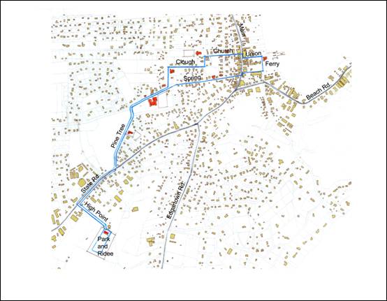
Figure 6 Proposed
Shuttle bus route
The bus route between the Park and Ride lot and the ferry can be re-directed to
accommodate a wider variety of users than just ferry riders. If the route followed Pine
Tree and Spring Street to the ferry instead of
_____________________________________________________________________________
*****************************************************************************
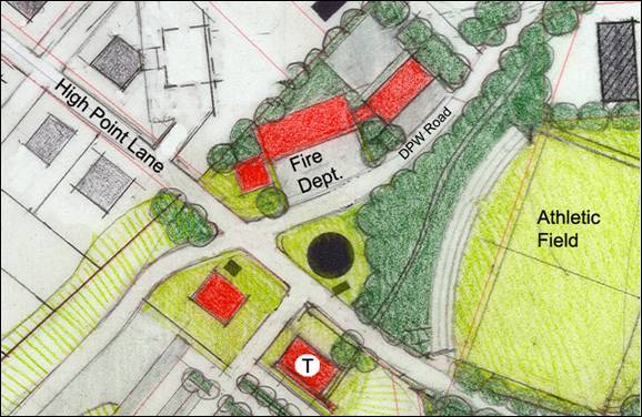
Figure 7 Possible location for new fire house
The current location of the fire department is especially impractical
and unsafe. It is located in the heart of town, on our most heavily traveled street. It is
adjacent to the post office and across from the hotel. In an emergency, it is very
difficult to bring the volunteers in to get the trucks and then to bring the trucks out to
the fire. Moreover, new trucks are required that cannot be accommodated in the old station
so it is imperative that a new site be selected very soon.
The best sites for emergency services would be out of the congested
downtown in a location that has good access to all parts of the town. Also, the site needs
to be large enough to accommodate all the vehicles including the new ladder truck and
ambulances as well. Because of the geography of Tisbury, the best locations seem to be in
the
Preliminary estimates suggest that 1 to 3 acres of land are needed to
house the vehicles and related service spaces. The town has some property available near
the water tower and there may be privately owned properties nearby that will serve.
The police department’s current location is even more constrained than the fire department and it would also benefit by relocating to a site out of the downtown area
_____________________________________________________________________________
*****************************************************************************
With a connector to Edgartown Road,
Gs station
Neighborhood convenience store
Professional offices
_____________________________________________________________________________
*****************************************************************************
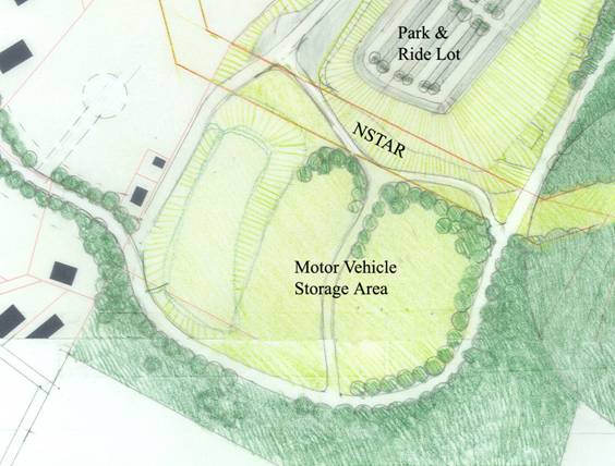
Figure 8 Proposed
Vehicle Storage Area at the landfill
To free-up land near State Road, we need to provide an alternative
site for the trucks, vans, and autos that are now stored in this area. One possible location for these uses is the
landfill. The landfill is capped and no buildings can be constructed on it for at least
twenty years. However, we can park vehicles there. There are more than five acres of land
within the landfill that the town can designate this area as an automotive storage zone
and encourage owners of trucks, trailers and other large scale vehicles and equipment to
locate there.
Much of this land is within our Zone II water protection area so care would have to be taken to insure that leaks from vehicles were not absorbed into the soil.
_____________________________________________________________________________
*****************************************************************************
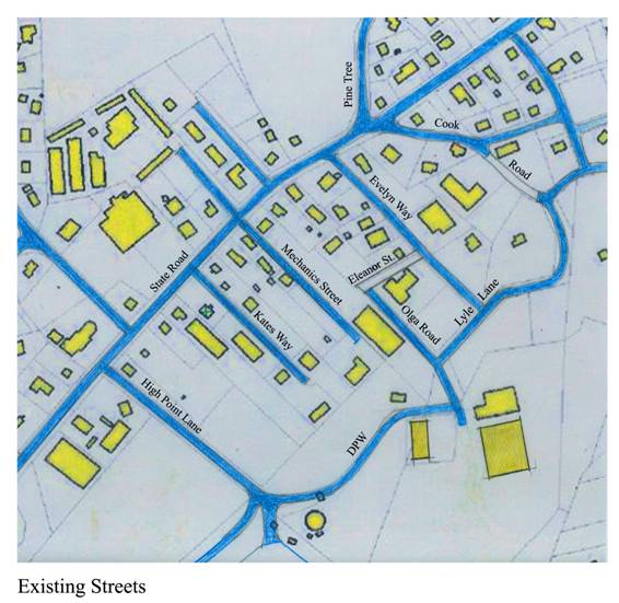
Today, the streets to the south of
***
Proposed neighborhood street Grid
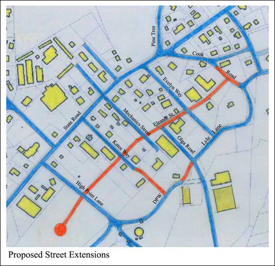
Figure 10 Proposed
neighborhood street Grid
An extension of
_____________________________________________________________________________
*****************************************************************************
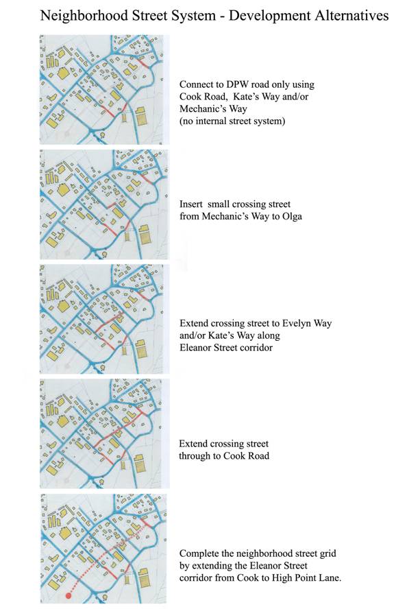
Figure 11
Possible sequence for development of a internal street system
_____________________________________________________________________________
*****************************************************************************
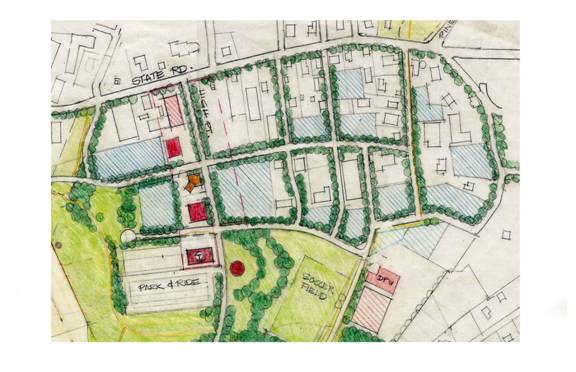
Figure 12 Blue
shaded areas indicate potential residential development sites.
More than seven acres of marginal and vacant land exists in the area
bounded by
With year-round commercial services within walking distance of this
area as well as schools, transit, parks and recreation facilities, it is a very attractive
location for new housing.
We are recommending that the zoning be revised to allow residential units to be built more compactly than is presently allowed (perhaps 10-12 units per acre instead of the usual 4).
_____________________________________________________________________________
*****************************************************************************
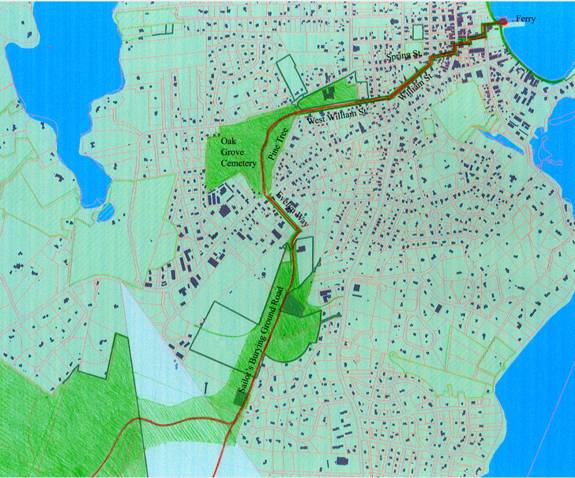
Figure 13 Proposed walking and biking trail and open
space network
There is a significant amount of undeveloped land in Tisbury that has
been protected through a variety of conservation measures as well as town-owned land that
has been purchased to protect our ground water aquifers.
However, much of this land is not open to the public. The public spaces, for
their part are often hard find and even harder to get to.
And, of course, when it comes to beach access, the amount of public land is
reduced to almost zero.
We should resist the temptation to use these undeveloped areas for
other purposes, no matter how urgent the need. Once you build on open land, it’s gone
and you can never get it back.
We need to find ways to both protect and expand our inventory of
protected lands and also to create a coherent system of linked access ways. We should also
find ways to join the open spaces and natural areas to the parks, walks and historic sites
within the town so these varied experiences are seen as part of a continuum and not
separate entities.
The above drawings suggest one method of integrating the
Sailor’s Burying Ground ancient way with town land, Land Bank property, the new
athletic field, the cemetery, the school, the
_____________________________________________________________________________
*****************************************************************************
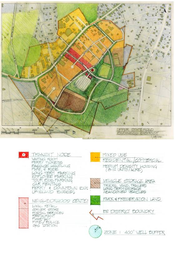
Figure 14 Upper
State Road Proposed Land Uses
_____________________________________________________________________________
*****************************************************************************
Please send your comments to the Planning Board at planning@ci.tisbury.ma.us
_____________________________________________________________________________
*****************************************************************************